Wildfire fuel management along Highway 99 near Emerald Estates starts Monday, September 22
Fuel management in Whistler
The Resort Municipality of Whistler has been conducting wildfire vegetation management projects on Crown and municipal lands since 2004 to reduce the risk of wildfire to our community. The primary goal is to reduce forest fuel loads within the wildland-urban interface to reduce the ability of fire to spread from the forest into the community and vice versa, and to make wildfires easier to fight. Fuel thinning will be discontinued when the fire hazard goes to extreme and will resume when the fire hazard is lower.
Sometimes projects need to burn some of the wood debris. We will alert the public through social media. There is no need to report smoke from fuel thinning projects.
Current projects
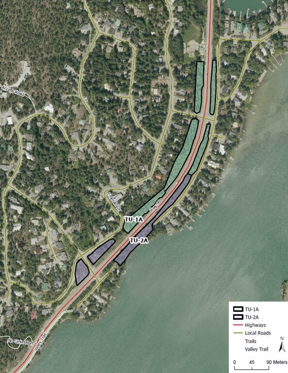
Wildfire fuel management along Highway 99 near Emerald Estates starts Monday, September 22
We will be managing vegetation to reduce wildfire risk along Highway 99 in two areas near Green Lake, in the Emerald Estates neighborhood, from Monday, September 22. The map below shows the locations. Work is anticipated to finish in late November but may be delayed due to weather or wildfire hazard.
This project is part of our wildfire mitigation work and reduces wildfire risk along Highway 99 — Whistler’s key transportation corridor.
We will minimize disruption as much as possible. Please check back for updates.
Stonebridge wildfire fuel thinning
Current status
Fuel thinning in the Whistler Stonebridge treatment unit is scheduled to commence on May 12, 2025 and will complete by end of summer 2025. The project may be interrupted if there is a high or extreme wildfire risk.
Impacts
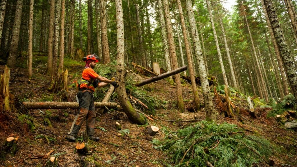
The treatment unit includes the area outlined in the map below. The second growth forest in that area is identified as “moderate” to “high” risk of ignition and wildfire movement. In fuel thinning, mature and deciduous trees are left, while lower branches are pruned, and unmanaged second-growth trees, ground brush and debris are removed. The work involves the use of heavy machinery, saws and a chipper resulting in loud noise at times. The crew will be following the RMOW Noise Bylaw hours of work.
During that time, the trails outlined in red in the map below will be closed to ensure the safety of the public. Closed trails include:
- Beaver Pass Trail
- Wip Me Snip Me Trail
- Rainbow Lake Trail
- Lower Beaver Pass Trail
Please respect the signs as the contractor will be cutting down trees and using heavy equipment. We will do our best to minimize disruption and all trails will be restored after the work is completed.
Funding
This project is funded in part by the Government of Canada through the Disaster Mitigation and Adaptation Fund.
Map

Completed projects
We’ve completed fuel management work in the following areas:
- Emerald west and Brio extension, 2025
- Whistler Cemetery, 2025
- Emerald west, 2024
- Brio, 2024
- Brio extension, 2024
- Panorama Ridge Brio, 2023
- Kadenwood Gondola, 2023
- Riverside Cheakamus Crossing, 2023
- Rainbow 1 neighbourhood project, 2023
- Cheakamus Lake Road Fuel Treatment, 2021
- Cheakamus Lake Road, 2020
- Spruce Grove/Lost Lake Park, 2019-20
- Nesters Hill, 2020
- High school site fuel thinning
- Taluswood wildfire fuel thinning, 2021-22
- Rainbow 2, 2022
Process and goals
Vegetation management focuses on leaving mature and deciduous trees, while removing ground brush and debris, pruning lower branches, and removing tight, unmanaged second growth trees. This is accomplished by:
- Reducing the number of trees in the stand to open the upper tree canopy and reduce ability of fire to move from tree to tree;
- Focusing on removal of small diameter trees and retaining fire-resistant species such as old growth, Douglas-fir and deciduous trees;
- Reduce fine woody surface debris, while retaining larger coarse woody debris for habitat and soil productivity;
- Pruning trees to reduce ladder fuels between the ground and the forest crown; and
- Removing dangerous trees to protect workers, while maintaining high value wildlife trees where possible.
In addition to reducing forest fuel loads, secondary objectives are to protect critical infrastructure and facilities in Whistler, restore open forest conditions and demonstrate the principles and practices of the FireSmart program.
Fuel breaks
The RMOW completed a study in 2012 which was incorporated into the Community Wildfire Resiliency Plan (PDF) to identify where landscape level fuel breaks should be created along forest service roads around Whistler. The focus is on reducing tree densities in unmanaged second growth, rather than removing old growth or deciduous trees. Thinning stands within 100 – 200 m of each side of the road reduces the fuel available to feed fire growth and creates safer, defensible areas for firefighting crews to work in.
Contact
Manager of Climate and Environment
Luisa Burhenne
lburhenne@whistler.ca